|
Please
tell us about maps and map resources we should include in
this list here.
Canada
Maps Available Online for Free
Government
of Canada Maps
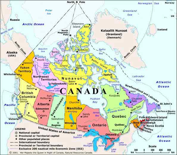
The
Government of Canada through their Department Natural
Resources Canada publishes an online atlas of detailed
maps for educational and research purposes.
Google
Maps of Canada
Includes
a zoom in and zoom out feature as well as latitude and
longitude.
Listings.ca
Maps
Includes
their own maps of provinces, territories and cities as
well as maps created by MapQuest.
Ontario
| Downtown
Toronto |
Ottawa
Alberta
| British
Columbia |
Manitoba
| New
Brunswick |
Newfoundland
| Northwest
Territories |
Nova
Scotia |
Nunavut
| Prince
Edward Island
| Quebec
| Saskatchewan
| Yukon
MSN
Maps of Canada
Microsoft® MapPoint® .NET is a hosted,
programmable XML Web Service for integrating maps,
driving directions, distance calculations, proximity
searches and other location intelligence into your
applications, business processes, and Web sites. Just
enter an address and postal code for a custom
map.
HRW
Holt , Rinehart and Winston Maps of
Canada
Includes
information on area, population, languages, literacy,
religions, life expectancy, currency, GDP, industry,
agriculture, arable land and natural
resources.
Merriam-Webster
Atlas Maps of Canada
Includes
information on Canada's flag history, government,
population projection, heads of state, GNP and land
use.
MapQuest.com
Maps of Canada
Find
maps of Canadian provinces and territories and zoom in
to view cities, rivers,lakes, railways, airports and
street names.
SuperPages.ca
Maps of Canada
Create
your own custom map by entering the city, street name
or postal code.
Historical
Maps of Canada
Electoral
Atlas of the Dominion of Canada
(1895)
From
the National Archives of Canada, this site provides
access to the first set of detailed maps prepared
by the Canadian government to show federal
electoral boundaries.
The
Canadian County Atlas Digital Project from McGill
University
Canada
in the Making
Includes maps from 1763, 1774, 1791, 1840 and
1867
Ontario
Maps Available Online for Free
The
Official Road Map of Ontario
RecreationalAtlas.com
Historical Maps of
Ontario from Ontario
GenWeb
These
maps record the historical changes in Ontario. Also
includes historical maps of counties, districts and
townships. Ontario was known as Upper Canada (from 10
Jun 1791 - 10 Feb 1841). Ontario was known as Canada
West (from 10 Feb 1841 - 1 Jul 1867)
Ontario
in 1713 |
Ontario
in 1830 |
Ontario
in 1851 |
Ontario
c.1970
North-Eastern
Ontario (c.1970)
| North-Western
Ontario (c.1970) |
South-Eastern
Ontario (c.1970)
| South-Western
Ontario (c.1970)
Historical Maps of
Ontario from Gentilcore, R. Louis; Head, C. Grant
(eds.). Ontario's History in Maps. University of
Toronto Press. 1984
Ontario
in 1813 |
Ontario
in 1857 |
Ontario
in 1888
The
Hodsoll Collection at MacMaster University Library
Historical
Maps of Canada from J. H. Bufford & Co. Map
Publishers circa 1880.
A
Map of New France in
A
General Chart of the Island of Newfoundland (1775) by
James Cook and Michael Lane
Surveyors
A
Map of Newfoundland in 1775
World
Maps Available Online for Free
World
Factbook from the
CIA
The
first classified Factbook was published by the CIA
(Central Intelligence Agency) of the United States in
August 1962, and the first unclassified version was
published in June 1971. Every country in the world is
listed along with a digital map and a
summary,geography,
people,government,economy,communications,transportation,military
and transnational issues of the country
World
Maps from Merriam-Webster
Atlas
Includes
information on the country's flag history, government,
population projection, heads of state, GNP and land
use.
World
Maps from HRW Holt , Rinehart and
Winston
Includes
information on area, population, languages, literacy,
religions, life expectancy, currency, GDP, industry,
agriculture, arable land and natural
resources.
World
Maps from Multimap in Great
Britain
GIS mapping service provides maps of Great Britain,
Europe and the World.
Canada
Maps to Purchase $
MapArt.com
Map
Art is proud to be a Canadian owned and operated
company based in Oshawa, Ontario, Canada. Their map
inventory includes the following maps available for
purchase:
Digital
Maps of Canada on CD
ROM
for
the following: Canada, Calgary and Edmonton,
Montreal, Ottawa, Toronto and Vancouver.
Folding
Maps
International
Maps
Road
Atlases
Street
Guides
Wall
Maps
MapTown.com
Map
Town is proud to be a Canadian owned and operated
company based in Calgary, Alberta, Canada. Their map
inventory includes the following maps available for
purchase:
Aeronautical
and Aviation Maps of Canada
Canada
Maps
Digital
Maps of Canada
Digital maps include the following products:
Digital
Ocean Charts
Etopo Canadian topographic maps
Memory Map Digital Mapping Software maps to plan
walks, build mountain bike trails, print maps,
plot your position on-road, off-road, or in the
city.
SoftMap GIS maps
Fugawi Moving Map Software
OziExplorer allows you to work with maps on the
computer screen that you create from scanned or
purchased digital maps. You can upload them into
your GPS unit.
iGage AllTopo Maps
Garmin International Digital Maps provide
geographic data in CD-ROM format that can be
viewed on a PC.
Globes
of Canada
floor and desk globes.
Nautical
Charts of Canada
They carry nautical charts of Canada's Pacific
Coast and Kootenays , Canada's Arctic Waters, Lake
of the Woods and Alberta Lakes Hydrographic Charts.
Road
Maps of Canada
Topographical
Maps of Canada
Geographicus.com
Based
in New York, New York,U.S.A. Geographicus.com sells
historical maps of Canada and provinces from the
1800's.
NationalGeographic.com
Map Machine
On
online GIS map creator brought to your by the National
Geographic Society, ESRI and WorldSat. You can create
world maps, climate and weather maps, political and
cultural maps, historical maps, battle scene maps and
ecoregions.
MapsandPrints.com
Art
Source International has over 20,000 original antique
maps and prints in stock and a history of over 20
years in the business.
CanadianGeographic.ca
The
Royal Canadian Geographical Society based in Vanier,
Ontario, Canada. Their Map
archive
includes maps in Adobe PDF format of The Old Canada
Road, French Shore in Nova Scotia, Yonge Street
Toronto, Land claims, Manitoba's Red River of flood,
1997. They also have Map
Games
and a history
of mapping in Canada.
The
Geography Network Canada
The
Geography Network Canada provides access to a rich
collection of digital maps, illustrating many
different qualities of our country. The map data is
hosted by a number of map servers distributed across
the country, providing you immediate access to the
latest map data available. Maps provided by ESRI
Canada.
|